The bridge that almost spanned
Seventy years ago, a feasibility study was released regarding construction of a transcontinental highway system that would stretch from the Gulf of Mexico to Canada along the Mississippi River.
The proposed Great River Road project would have changed the face of Monroe County had it been implemented.
It was the first of three post-World War II, major-impact projects that never came to be. The second was a bridge that would have spanned the Mississippi River from Crystal City, Mo., into Harrisonville.
The third, and most well-known locally, was an effort to build an airport near Waterloo. Speculation about the airport stalled and ultimately doomed the reality of another Mississippi River crossing in Monroe County south of the Jefferson Barracks Bridge.
With many resources in the early 1940s being diverted to the war effort, America found itself in a housing shortage following World War II while simultaneously experiencing an economic explosion. As materials became available, houses began to spring up in previously unoccupied areas around the country’s urban centers as well as people with money to buy them. The growing availability of automobiles, coupled with the outflow of populations from cities to rapidly growing suburban developments, led to a federal push for roads to accommodate commuters.
In October 1951, “Parkway for the Mississippi: A Report to the Congress” was published by a joint effort from the Bureau of Public Roads (now the Federal Highway Administration) and National Park Service outlining the feasibility of a “modified type of parkway development…designed expressly for tourist travel and to conserve and develop the recreational resources of the region” as a response to the new national interest in automotive travel.
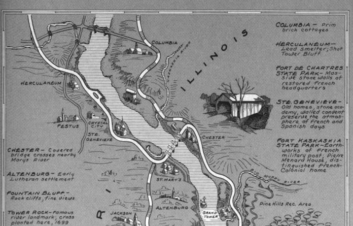
The proposed project involved construction of new, paved highways in areas along the route. One path would have created a highway from the Chester Bridge through Prairie du Rocher and the Bottoms before winding up the bluffs to Waterloo, then Columbia and up the Mississippi River in Illinois past Alton.
The national parkway through the 10 river states was rejected in favor of a “scenic route” concept with a Great River Road designation system consisting of road signs marking the regions and areas of interest on a state-by-state basis using existing roads.
The proposed bridge in Harrisonville was going to be built in conjunction with the Great River Road parkway, and then as a stand-alone project for Missouri and Illinois when funding and logistics for the larger effort failed to gain traction.
The first post-war mention of a system that could facilitate such a bridge is found in the Feb. 21, 1946 issued of the Waterloo Republican. State legislators and local dignitaries met with engineers “to discuss plans for a paved highway from East St. Louis to Chester by way of the American Bottom along the bluffs through Valmeyer, Chalfin Bridge, etc., to connect with Route 3 at Chester.”
Interest in developing the area continued even after it became official in 1954 that federal funding would only provide for decoration, not construction, of a Great River Road. The Bi-State Development Agency released a study in February 1963 proposing a toll bridge from Missouri to the Bottoms. Due to lingering questions that arose in 1955 challenging the agency’s scope and authority when it tried to acquire the McKinley Bridge near Venice, the agency’s Harrisonville bridge proposal never gained a proper foothold.
The idea was not abandoned, though, and it spawned the Missouri-Illinois-Jefferson-Monroe Bridge Commission. It was created by an act of Congress in late 1966 to “plan, construct, maintain and operate a bridge and approaches thereto across the Mississippi River at or near Crystal City, Missouri, at a point deemed by the commission as most suitable to the interests of the citizens.”
The commission was one of nine metropolitan-area “regional government agreements” studied in a publication prepared for the Office of Research and Development of the U.S. Environmental Protection Agency. The report, finished in the mid-1970s, reveals one possible reason the bridge was never built.
The study reported that the “current planning activities of the commission have been hampered by the indecision regarding the location of additional airport facilities either in Waterloo, Illinois area… or through expansion of Lambert Field in St. Louis County. The last meeting of the commission was held in April 1972, and no further meetings will be held until the airport decision has been made.”
The airport was never built in Monroe County, but another explanation for why the bridge never came to be is through natural causes. In July 1973, the Mississippi River crested at record levels for that time, possibly dissuading such a project in a floodplain.
All three projects would have made far-reaching impacts on the Monroe County’s culture, population, economy and myriad unknown aspects. But as Robert Frost said in one famous poem about the nature of forward movement: “Yet knowing how way leads to way/I doubted if I should ever come back.”

