Rising river causing concern
The Mississippi River is expected to crest at 46 feet in St. Louis on June 5, according to the National Weather Service and U.S. Army Corps of Engineers.
It is expected to stay at that level until June 13, the Monroe County Sheriff’s Department posted on Facebook Friday afternoon.
“We have not received any information on a crest being higher than 46 feet at this time, and we have not received any information that our levee will be compromised,” Monroe County Sheriff Neal Rohlfing said. “There are no plans or discussions of breaching any levee at this time.”
Since that would be the second highest crest on record, behind only the crest of 49.58 feet during the Flood of 1993, voluntary evacuation orders have been issued to Monroe County residents who live in the floodplain.
“There are a couple areas of concern with the state, and that’s the reason for the voluntary evacuation,” Monroe County Emergency Management Agency Director Ryan Weber said Tuesday afternoon. “We knew they were going to raise it up from 44 feet, but we didn’t know how far.”
Flood stage is 30 feet in St. Louis, while major flood stage is 40 feet. The river was at 42.1 feet on Tuesday morning.
If the river does rise to 46 feet, evacuation orders would become mandatory.
“If and when the Mississippi River actually reaches the 46 feet mark, we will begin evacuating the Monroe County bottoms south of Carr Creek,” the Monroe County EMA posted Wednesday afternoon on Facebook. “We are working with the Red Cross to have a shelter set up before the evacuation order is given and will provide that information once the location is confirmed.”
The MCSD provided more detail on the evacuation plan.
“We are asking all residents and property owners to begin the evacuation,” the department posted on Facebook. “It will not be mandatory until the river crests, which is projected next week.”
The original statement regarding no imminent evacuation was made after a conference call with the National Weather Service on Tuesday afternoon. Based on that call, Weber said the situation should improve in the next week or so.
“After the next 24 hours of rainfall, there should be no significant area-wide rainfall following that,” he explained. “So it should allow for the rivers to start to drop. That will ease the tension a little bit, but we would rather people start to voluntarily move stuff out. The switch can flip any time.”
With the river expected to rise so high, the Monroe County EMA is seeking volunteers to fill sand bags from 5-9 p.m. Wednesday and 9 a.m. to 1 p.m. Thursday. Volunteers should report to the mobile command post at Rock City in Valmeyer.
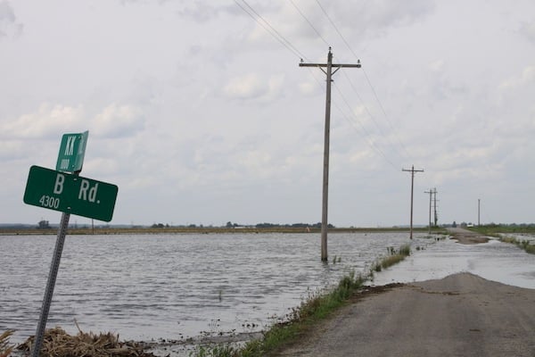
The water has also forced several road closures in the lower portion of the county due to seep water.
“We are experiencing flooding on numerous roads in the river bottoms due to the Mississippi River flood stage,” Rohlfing said. “Please refrain from driving in the river bottoms unless you are a resident. Also, please do not drive through any standing water or around any barricades for your safety.”
Weber said the road closures are mostly on side roads. He said there should be no more closures on Bluff Road, which is currently closed from Hanover Road to HH Road and further south from Kidd Lake Road to Kaskaskia Road.
The Monroe County EMA also had to contend with sand boils, which occur when water under pressure wells up through a bed of sand, over the weekend.
Weber said there were three to five sand boils in the Harrisonville levee district over the weekend, but they were all minor.
Due to all those issues, the Monroe County Sheriff’s Department is issuing permits for people who need to be in the Bottoms. That will help deputies identify those individuals during extra patrols.
“We’re trying to limit non-essential people down here sightseeing and driving through water because we have a number of roads that have water on them,” Rohlfing explained. “So we’re trying to discourage all that and just leave it to the people who need to move things to higher ground and those who have a reason to be down here.”
Rohlfing said those permits for residents and property owners in the floodplain are available at Valmeyer Village Hall and the mobile command post at Rock City.
“With the new crest issued for the Mississippi River at 46 feet for June 4 we are asking all residents and property owners to begin the evacuation,” Rohlfing said. “It will not be mandatory until the river crests, which is projected next week. All non-essential traffic needs to stay out of the flood plain until further notice.”
Free storage units are available for residents planning to evacuate. Call 618-709-3725 or 618-939-FIND for more information.
The Monroe County EMA is also coordinating with Helping Strays and the Monroe County Fair Association to set up a pet shelter at the fairgrounds. Plans are still in the works.
Additionally, on Thursday, Gov. JB Pritzker deployed 200 National Guard service members throughout the state to help with flooding.
As the situation continues to develop, Weber assured residents the county will monitor all concerns related to the Mississippi River.
“We’re watching it,” Weber said. “We’re reacting to it.”
Flooding in surrounding areas
To the east, the National Weather Service reported the Kaskaskia River in New Athens was at 89.24 feet on Thursday. Flood stage is 79 feet. The record flood total is 95.6 feet.
Just north of Monroe County, an informational meeting on the flood for residents of Dupo, East Carondelet and Sugarloaf Township took place Thursday night at Dupo High School.
At the meeting, the St. Clair County Emergency management agency said it had “no expectations of levee failures or overtopping at this time.”
Floodgates have been put up in the area, including on north end of Dupo.
St. Clair County EMA Director Herb Simmons told those at the meeting that there are no evacuation orders in place because the flooding appears manageable.
“The most important message we’re going to give you tonight is don’t run home and pack your bags and say you’ve got to move,” he said.
South of Monroe County, the Chester Bridge reduced to one lane starting Thursday due to the rising river levels. Beginning June 1, the bridge will be closed completely.


