Preserving Piggott’s Fort
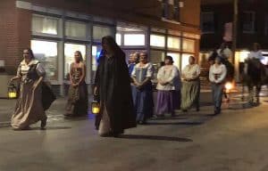
Last week, local residents and those interested in Monroe County’s heritage attended to the dedication of a sign at the site of Fort Piggott along Bluff Road across from Sackman Field Airport in Columbia.
The dedication was part of a larger, ongoing project to highlight various historical locations along the Kaskaskia-Cahokia Trail. Though, as local historian Dennis Patton described, the fort itself holds a rich history.
Patton, who served as principal of Columbia High School from 1982-2004, spoke about how he’s become interested in local historic preservation over the years, joining the Columbia Heritage Preservation Commission following his retirement.
Patton recalled how he and a friend of his purchased the Sand Bank School along Bluff Road in Columbia, restoring the one-room schoolhouse and learning a great deal in the process.
“It was in really pretty poor shape, and my friend and I bought it to restore it,” Patton said. “In the process of restoring that, people started bringing us information about the school. One of the items I got was the actual land grant that the school was built on. It was first built as a log cabin in like 1815.”
From the land grant, Patton learned that the school sat along the Kaskaskia-Cahokia Trail, of which he was unfamiliar.
He set out to find out more about the trail, compiling information from a number of other sources and making a proposal to the state to get the trail designated as a state historic and scenic bi-way.
While the Columbia Heritage Preservation Commission started this effort, another group – the Kaskaskia-Cahokia Trail Coalition – helped push it forward, bringing folks from Monroe, Randolph and St. Clair counties together to communicate its significance.
“Our goal was to make people aware of the trail, promote tourism along the trail and then also to mark different historical sites that were along the trail with signage,” Patton said.
Patton noted that much of the credit for getting this signage put up goes to former Waterloo Mayor Tom Smith, who serves as a chairperson for the coalition.
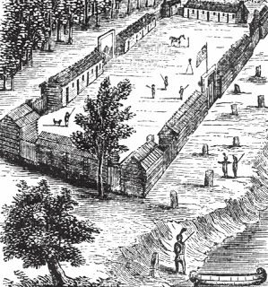
The most recently dedicated of these signs now stands at Fort Piggott – also known as Fort Great Run – named after founder James Piggott.
As the newly posted sign explains, Piggott served as a captain in the American Revolutionary War. A Connecticut native, he moved to Pennsylvania during the war, later traveling to Kentucky as he served in battles against American Indian tribes.
He, along with 17 other families, ultimately arrived in the American Bottoms around 1783, establishing a fort where the Grand Ruisseau creek – now known as Carr Creek – emerged from the bluffs.
Patton explained how the fort was among the strongest in all the Northwest Territory which stretched from Ohio to Illinois and north to Minnesota. The new sign notes that it was one of the largest forts built by Illinois settlers, with cannons and small arms used to defend against local tribes.
Settlers, as Patton described, would come to the fort and reside nearby, using it as shelter when needed.
This settlement would grow and develop over the years, eventually become the community of Columbia.
“It grew. It was a fort, and then around 1795 there was a big treaty with the Indians, and when they had that treaty, people started moving out of the fort,” Patton said. “I think there was 17 families, about 40 people living in the fort when they first built it, but more and more people came, and they would start building log cabins all around the fort. That little settlement became known as Eagle, and then from that the name Eagle Precinct came, then that Eagle Precinct name was changed to Columbia Precinct later on.”
The Piggott Fort sign also explains how, in 1790, Piggott and the fort’s other inhabitants petitioned to request grants of land to the settlers, with 400 acres being granted to every settler with an additional 100 granted to men enrolled in militia service.
Piggott’s fort is no longer standing, and its precise location isn’t currently known, though, as the sign states, the spot currently recognized to be the site of the fort is located on Piggott’s land grant and is thusly presumed to be near this fort’s actual location.
Patton noted a number of other various facts about the fort and its history as well as the site where the new sign is located.
The foundations of the 1820s Schneider Family German-style barn are located at the site, roughly the center of Piggott’s land.
Though the barn itself has fallen down, Patton noted that a beam from the barn was sent to the University of Illinois to be carbon dated and would appear to date back somewhere between 1770 and 1800.
Patton also offered further information on the Kaskaskia-Cahokia Trail Coalition and its efforts to preserve local history.
He recalled accepting the Driefus Award from Landmark Illinois in Chicago on behalf of the coalition and the Columbia Heritage and Preservation Commission for the groups’ efforts to preserve and protect the trail, described as “one of Illinois’ most endangered landmarks.”
He also expressed his reasoning for wanting to help with local preservation.
“Luckily I found a lot of like-minded people in the three counties that were interested enough to form this not-for-profit coalition to keep this dream alive that we could let people know that we have a beautiful area of the state. It’s a beautiful drive down Kaskaskia Road or down through the bluffs,” Patton said. “And when you take that ride, you’re gonna be going back into history even further back, you’re gonna be going back in history thousands of years to when Native Americans traveled through this area.”
For more information on the Kaskaskia-Cahokia Trail Coalition, visit the group’s Facebook page or visit kctrailillinois.org.
