Region on high alert for flooding along Mississippi River
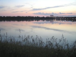
A photo of high water along the Fish Lake levee in Columbia in July 2008.
Large amounts of precipitation throughout the Upper Midwest have resulted in higher water levels for the Mississippi River. That water is flowing south, causing concern for flooding in the St. Louis region and beyond.
The river was at 29.6 feet in St. Louis on Friday morning, according to the U.S. Army Corps of Engineers River and Reservoir Report. That is an increase of 2.63 feet since the same time on Thursday. With even more rain predicted for much of the Midwest on Friday, the river is expected to rise to 36.2 feet on Sunday before cresting near 40 feet on Tuesday, according to the National Weather Service. Forecasts call for the river to remain above 30 feet until around June 11.
If the prediction holds true, it would be the highest the river has been in several years. It crested at 36.7 feet in St. Louis during the summer of 2008, and some flooding issues were reported in and around Monroe County. River stage predictions take into account water currently in the system (including Thursday’s rain), as well as forecasted precipitation up to Saturday morning.
During the Great Flood of 1993, the river crested at a record 49.6 feet in St. Louis.
Flood stage is 30 feet in St. Louis, and 40 feet is considered “major flood stage.”
The Corps of Engineers St. Louis District has activated its Emergency Operations Center in St. Louis. Some locks on the Mississippi River north of St. Louis have also been closed as water has overtopped their gates.
“The EOC activation allows the Corps to provide teams and resources to support local flood fighting efforts,” the Corps stated in a Friday news release. “Corps personnel have contacted affected levee districts to coordinate flood fighting activities and ensure supplies such as sand bags, pumps and plastic are available if needed.”
To view the regularly updated River and Reservoir Report online, visit http://mvs-wc.mvs.usace.army.mil/dresriv.html .
The Illinois Department of Transportation will be monitoring state roadways over the next 48 hours for possible closure due to flooding.
“Travelers are advised to consider alternate routes or allow additional time to travel known flood prone areas,” IDOT stated in a news release.
Visit online at www.dot.il.gov/road/closures.txt for the latest information on roadway closures throughout Illinois.

